TORONTO, CANADA (By Orvana, 28.Jan.2026, Words: 890) — Orvana Minerals Corp. reported the recently conducted Induced Polarization (“IP”) and Magnetotelluric (“MT”) geophysical survey at the company’s Taguas project located in the San Juan Province, Argentina outlined a north–south–trending corridor characterized by elevated chargeability and a deep zone of moderate to low resistivity.
These geophysical responses can, in some geological settings, be associated with sulfide-bearing systems. With the geophysical work complete, the company has now begun its first deep drilling program at Taguas to find out whether these signals are related to a potential deep porphyry copper-gold system.
Juan Gavidia, CEO of Orvana, stated: “The integration of deep-penetrating geophysics with geological and geochemical datasets has significantly enhanced our drill targeting at Taguas, and this initial deep drilling campaign represents an important step in testing the project’s potential for copper-gold mineralization at depth.”
Strategic context
- The company repositioned the Taguas project to evaluate its broader potential, extending beyond the near-surface oxidized gold-silver resource outlined in the 2021 Preliminary Economic Assessment (dated 29 Dec. 2021, available at www.sedarplus.ca) to include the underlying sulfide mineralization and the potential deep porphyry copper-gold system.
- The company completed an updated geological model for the Taguas Project and conducted a geophysical survey, designed to identify potential deeper targets to a depth of 1,500m.
- Results from the geophysical survey, combined with the recent review of historical exploration data have been used to prioritize key targets for the initial deep drilling, which is now underway.
Geological modeling results
- The relogging of historical drill holes combined with systematic VNIR–SWIR spectral scanning (this technique maps alteration mineral zonation and vectors toward the concealed core of a deep porphyry system) has successfully identified coherent alteration and geochemical vectors consistent with a possible porphyry style mineralization along a 2.5-km north–south corridor extending from Cerro Campamento to Cerro IV.
- Alteration mineralogy derived from SWIR data reveals consistent gradients across all three areas, indicating increasing temperature conditions and proximity to a magmatic heat source. These mineralogical trends are spatially coincident with increasing Cu and Mo values at depth, the presence of early B-type quartz veinlets (indicate proximity to the high-temperature magmatic–hydrothermal core of a potential deep porphyry system), and favorable structural settings, collectively supporting the interpretation of a magmatic–hydrothermal system at depth that warrants further evaluation through drilling.
- The integration of alteration vectoring, veining styles, and multielement geochemistry defines a robust exploration framework that is internally consistent across Cerro Campamento, Cerro III, and Cerro IV.
- While the frequency of deep drilling is limited, particularly at Cerro III, the convergence of SWIR-derived thermal gradients, Mo & Cu enrichment, and veinlets presence is considered encouraging in the context of the Company’s exploration model. These results support further evaluation through targeted geophysical surveys and deeper drilling to validate and refine vectors toward a concealed porphyry intrusive center beneath the epithermal system.
- The geological modeling results described suggest a coherent exploration target at depth, which the company is now testing through its initial deep drilling program.
Geophysical results
- Ridgeback Geofísica Argentina S.A., an affiliate of Southernrock Geophysics was engaged by Orvana to conduct Magnetotelluric (MT) and Induced Polarization (IP) surveys across the southern portion of the Taguas property.
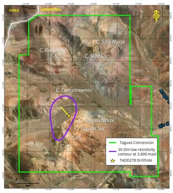
- The survey covered the full 4km2 area of interest between Cerro Campamento and Cerro Cuarto (part of Cerros Taguas), using a 400m × 400m grid.
- MT survey provided 3D models of subsurface resistivity down to depths of approximately 1,500m. IP survey generated chargeability models to shallower depths reaching around 800m or 1,000m.
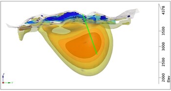
- The integrated interpretation of IP and MT data outlines a north–south–trending corridor of elevated chargeability coincident with a deep zone of moderate to low resistivity (images 1A and 1B). This anomaly remains open both to the north and south and is interpreted as being consistent with the possible presence of sulfide mineralization at depth; however, drilling is required to determine its nature, extent, and economic significance.
- The geophysical results are spatially coincident with multiple independent indicators of porphyry copper potential identified at surface, including widespread veining, hydrothermal alteration, and anomalous copper and molybdenum geochemistry. Near-surface zones of high resistivity are interpreted as silicification related to epithermal alteration, while deeper conductive domains are considered compatible with more interconnected sulfide mineralization, potentially representing the nucleus of a porphyry system.
- In conclusion, the recent geophysical survey has identified significant subsurface features that align with geological models commonly used in the exploration of copper-gold porphyry systems. While these results do not confirm the presence of an economically viable mineral deposit, they have helped the company better define target areas for deeper test drilling.
Drilling program
- The current drilling program is designed to evaluate the potential deep porphyry copper-gold system at the Taguas property for the first time.
- Deep drilling will test zones exhibiting geological and geophysical characteristics commonly associated with copper–gold porphyry systems. Drilling commenced in Jan. 2026, with a preliminary program of approximately 4,500m using one drill rig, which the company expects to complete by Apr. 2026, subject to drilling conditions and logistics.
- The drill rig has commenced operations from the first platform. The initial hole targets the core of the low resistivity between Cerro Taguas Norte and Cerro Campamento, with a planned length of 1,500m.
- Drill results from the program are expected to be released as they become available, subject to analysis and verification.
____________________